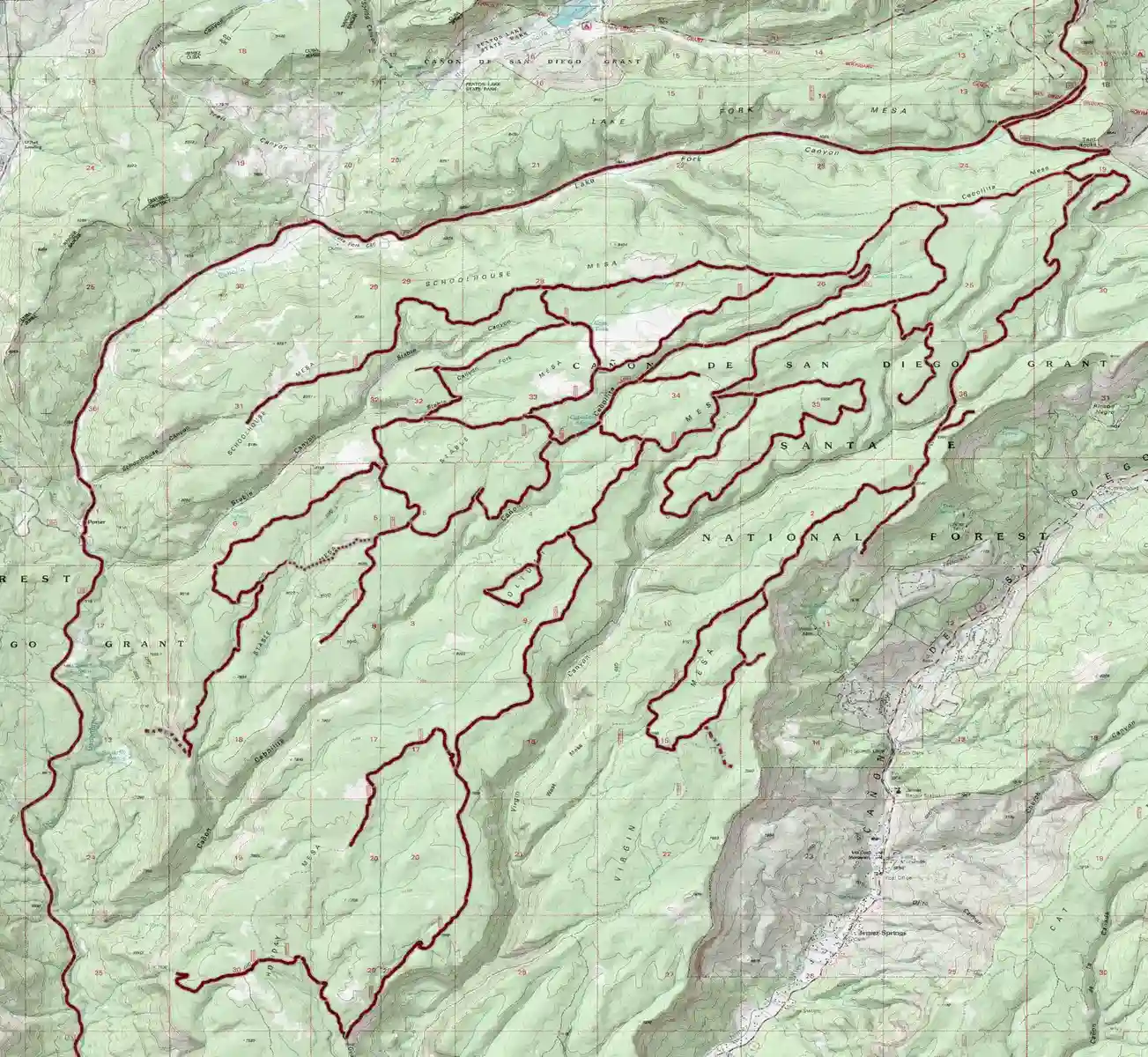
Trailhead: FR376/FR604A Distance: 1.18 mi. Climb: 378 ft.
FR376/FR604A to FR604/FR607
604
Trailhead: Hwy126/FR376 Distance: 1.28 mi. Climb: -196 ft.
To FR376/FR604A Expect campers along this route unless the gate is closed.
376 604A
Trailhead: Hwy126/FR376 Distance: 1.3 mi. Climb: -200 ft.
To FR376/FR604A Expect campers along this route unless the gate is closed.
376 604A
Trailhead: Hwy126/FR376 Distance: 1.7 mi. Climb: 76 ft.
To FR376/FR604A goes thru the trees up on the hillside avoiding most of the campers.
376 604A 604c
Trailhead: Hwy126/FR376 Distance: 1.84 mi. Climb: -225 ft.
To FR376/FR604A Expect campers along this route unless the gate is closed.
376 604A
Rides #6-9 are options to get from Hwy 126 to FR604/FR607.
Trailhead: Hwy126/FR376 Distance: 2.46 mi. Climb: 374 ft.
To FR604/FR607 Expect campers along this route unless the gate is closed.
376 604A
Trailhead: Hwy126/FR376 Distance: 2.47 mi. Climb: 378 ft.
To FR604/FR607 Expect campers along this route unless the gate is closed.
376 604A
Trailhead: Hwy126/FR376 Distance: 2.74 mi. Climb: 391 ft.
To FR604/FR607 Expect campers along this route unless the gate is closed. Adds a 2 viewpoints
376 604A
Trailhead: Hwy126/FR376 Distance: 2.83 mi. Climb: 444 ft.
To FR604/FR607 goes thru the trees up on the hillside avoiding most of the campers. Allows access to all routes even if the gate is closed.
376 604A 604c
Trailhead: FR604/FR607 Distance: 3.87 mi. Climb: 209 ft.
Easy out and back ride with view at the end. Great for kids, beginners or add to the end of a longer ride.
607 938C 938CD
Trailhead: FR604/FR604J Distance: 5.65 mi. Climb: 392 ft.
Goes to a loop on a small mesa. Do the loops counter-clockwise. There are two short climbs on the return loop.
604 605 605E 605 604J
Trailhead: FR376/FR604A Distance: 6.13 mi. Climb: 386 ft.
Out and back to a cool carving from 1920. Route parallels 376 west of 604 . Expect campers. Great for kids or beginners.
604B 376 604B
Trailhead: FR604/FR607 Distance: 6.24 mi. Climb: 558 ft.
Goes down the mesa meeting a side canyon of Virgin Mesa then returns up Virgin Mesa. It has one short rocky section. Return is gradual, except at the top of the canyon.
607 938C 607
Trailhead: FR606/FR605HA Distance: 7.18 mi. Climb: 533 ft.
Does a loop on upper Holiday Mesa. Do the loops counter-clockwise. Good if you are camping along 606.
605HA 605H 605 605G 605GA 605G 605 605H
Trailhead: FR606/FR605H Distance: 7.18 mi. Climb: 590 ft.
Does a loop on upper Holiday Mesa. Do the 2nd loop counter-clockwise. Good if you are camping along 606.
606 605H 605 605G 605GA 605G 608G 608
Trailhead: FR604/FR607 Distance: 8.32 mi. Climb: 536 ft.
Goes to a loop on a small mesa. Do the loops counter-clockwise. There are two short climbs on the return loop.
607 604J 605 605E 605 605B 606 604
Trailhead: Hwy126/FR376 Distance: 8.71 mi. Climb: 594 ft.
Out and back to a cool carving from 1920. Route parallels 376. Expect campers. Great for kids or beginners.
376 604A 604B 376 604B 604A 376
Trailhead: Hwy126/FR376 Distance: 9.82 mi. Climb: 799 ft.
Out and back to a cool carving from 1920 along FR376 using the route thru the trees. Route parallels 376. Expect campers. Side trips north of FR376 go to motorcycle trials areas.
376 604A 604c 604B 376 604B 604c 604A 376
Trailhead: Hwy126/FR376 Distance: 10.13 mi. Climb: 632 ft.
Goes to San Antonio Hot Spring. Hike the last part up to the spring. Hide your bike or carry it up to the spring with you.
376North
Trailhead: FR604/FR607 Distance: 13.37 mi. Climb: 1455 ft.
Out and back with views to a repeater site on Virgin Mesa. Side trip to tent rocks. Optional hike down to tent rocks. Route uses 2 side canyons to get on and off the mesa.
607 st 607A 607A 607 607B 607 607A st 607
Trailhead: FR604/FR607 Distance: 15.17 mi. Climb: 917 ft.
Goes to Canon Cebollita via Stable Mesa. The section south of the fork is single track. Returns via 606 up Canon Cebollita
604 611 611A 606 st 606 605B 605 604
Trailhead: FR604/FR607 Distance: 15.48 mi. Climb: 960 ft.
Goes to Canon Cebollita via Stable Mesa. The section south of the fork is single track. Returns via 606 up Canon Cebollita with a diversion on 605H, 605HA.
604 611 611A 606 st 606 605H 605HA 606 605B 605 604
Trailhead: FR604/FR607 Distance: 16.02 mi. Climb: 741 ft.
Goes out Schoolhouse Mesa to the top of Schoolhouse Canyon for a great view.
604 604N 604 604? 604 606 655B 604 604
Trailhead: FR604/FR607 Distance: 16.35 mi. Climb: 1074 ft.
Goes to log camp on Stable Mesa and returns on the same route.
604 605 606 611 606 604
Trailhead: FR604/FR607 Distance: 16.54 mi. Climb: 1049 ft.
Goes out Schoolhouse Mesa then crosses Stable Mesa at Cass Tank and then drops into Cebollita Canyon and goes down it on single track. Return is back up the canyon .
604 604N 604 611 611A CC 606 605B 605 604
Trailhead: FR604/FR607 Distance: 18.24 mi. Climb: 1066 ft.
Goes down Stable Mesa to Tovakwa Ruins, back tracks and then returns via upper Cebollita Canyon.
604 611 611BA 606A 606 605B 605 604
Trailhead: FR604/FR607 Distance: 18.26 mi. Climb: 1128 ft.
Goes out Schoolhouse Mesa to the top of Schoolhouse Canyon for a great view of the canyon then does a loop with more views on the end of the mesa.
604 605 605B 606 604 604N 604 604? 604
Trailhead: FR604/FR607 Distance: 18.38 mi. Climb: 1131 ft.
Goes down Stable Mesa to log camp ruin, back tracks and then returns via upper Cebollita Canyon.
604 611 611A 606 606A 611BA 611 606 605B 605 604
Trailhead: FR604/FR607 Distance: 18.68 mi. Climb: 1694 ft.
Out and back down Virgin Canyon
607 938F 607
Trailhead: FR604/FR607 Distance: 20.27 mi. Climb: 1358 ft.
Covers most of the roads on upper Holiday Mesa
604 604J 605 605E 605 605G 605GA 608G 608G 608GA 608 606 605H 605HA 606 605B 605 604
Trailhead: FR604/FR607 Distance: 20.31 mi. Climb: 1698 ft.
Goes to Amoxiumqua ruins on Virgin Mesa via 938C. This route has a gnarly section of road to get on and off of Virgin Mesa.
607 938C 607 1614 607 609 607 1614 607F 607
Trailhead: FR604/FR607 Distance: 20.51 mi. Climb: 1317 ft.
Goes out Schoolhouse Mesa then crosses Stable Mesa further down and then drops into Cebollita Canyon and goes down it on single track. Return is back up the canyon .
604 604N 604 604P 611 611B 611BA 606A 606 CC 606 605H 605HA 606 605B 605 604
Trailhead: FR604/FR607 Distance: 20.99 mi. Climb: 1301 ft.
Goes down east side of Holiday Mesa to the Kwastiyukwa ruins (Giant Footprint). Return route is by 608 to the log camp
604 604J 605 608G 608GA 608 656G 608 656A 656 608E 608F 608 606 605B 605 604
Trailhead: FR604/FR607 Distance: 21.25 mi. Climb: 1242 ft.
Goes to near the end of Stable Mesa with views to the east and west.
604 604N 604 604P 611 611? 611 604 606 605B 605 604
Trailhead: FR604/FR607 Distance: 21.54 mi. Climb: 1239 ft.
Goes to near the end of Stable Mesa with views to the east and west using different routes.
604 604J 605 605B 604 604N 604 604P 611? 611 604
Trailhead: FR604/FR607 Distance: 23.03 mi. Climb: 1587 ft.
Goes down east side of Holiday Mesa to the Kwastiyukwa ruins (Giant Footprint). Return route is by 656
604 604J 605 605B 606 604 604N 604 604P 611 611? 611 604
Trailhead: FR604/FR607 Distance: 25.22 mi. Climb: 2337 ft.
Goes to Amoxiumqua ruins on Virgin Mesa via 2 single track side canyons to avoid nasty section of 607. A side trip goes to tent rocks. This route uses a decommmision part of 607.
607 938C 607 ST 607A 607 607B 607 1615 607 607# 607 609 607 1614 607 607F 607 607A ST 607
Trailhead: FR604/FR607 Distance: 27 mi. Climb: 1823 ft.
End to end on Holiday Mesa going to Guadalupita Mesa with great views of the Gilman Tunnels and an overlook on the far west side of the mesa with views to the west and north
604 604J 605 608G 608GA 608 656G 608 656 608E 608F 608 605 604
Trailhead: FR604/FR607 Distance: 28.57 mi. Climb: 2547 ft.
Goes to Virgin Mesa via 938C and side canyon with side trip to tent rocks the to Amoxiumqua ruins on Virgin Mesa with side trip on 607B.
607 938C 607 ST 607A? 607A 607 607B 607 1615 607 607# 607 609 607 1614 607 607F 607 607A ST 607
Trailhead: FR604/FR607 Distance: 30.14 mi. Climb: 2724 ft.
Goes to Virgin Mesa via 938C including 938CD and side canyon with side trip to tent rocks the to Amoxiumqua ruins on Virgin Mesa with side trip on 607B.
607 938C 938CD 938C 607 ST 607A? 607A 607 607B 607 1615 607 607# 607 609 607 1614 607 607F 607 607A ST 607
Trailhead: FR604/FR607 Distance: 32.7 mi. Climb: 2107 ft.
Goes part way down Holiday Mesa then over to Stable Mesa to near the end then up the other side to Schoolhouse Mesa out to a view at the end of it , back on Schoolhouse Mesa.
604 604J 605 608G 608 606 606A 611BA 611B 611 611? 604P 604 604?
Trailhead: FR604/FR607 Distance: 33.15 mi. Climb: 2107 ft.
Half way down Holiday Mesa then up the other side to Stable Mesafor part of it, up the other side to Schoolhouse Mesa out to a view at the end of it , back on Schoolhouse Mesa.
604 604J 605 608G 605GA 608 608F 608FA 608H 608 606 606A 611BA 611B 611 611? 604P 604 604?
Trailhead: FR604/FR607 Distance: 42.15 mi. Climb: 3762 ft.
Goes to Virgin Mesa via 938C including 938CD then Virgin Canyon. Uses side canyon with side trip to tent rocks the to Amoxiumqua ruins via 607dc on Virgin Mesa with side trip on 607B.
607 938C 938CD 938C 938F 607 ST 607A? 607A 607 607B 607 1615 607 607# 607 609 607 1614 607 607F 607 607A ST 607
Trailhead: FR604/FR607 Distance: 42.31 mi. Climb: 2800 ft.
Holiday Mesa to Guadalupita Mesa then up the other side to Stable Mesa and back on Stable Mesa. Has side trips for views.
604 604J 605 608G 608GA 608 656G 608 656 608E 608F 608 606 606A 611BA 611B 611 611? 604P 604 606 605B 605 604
Trailhead: Hwy4/Hwy485 Distance: 43.09 mi. Climb: 2917 ft.
This route circles all the mesas. It goes up hwy 485 (paved) to 376 thru the Gilman Tunnels to Porter then up Lake Fork Canyon to hwy 126 (paved), to La Cueva, then down hwy 4.
hwy485 376 hwy126 hwy4
Trailhead: FR604/FR607 Distance: 47.83 mi. Climb: 3163 ft.
Holiday Mesa to Guadalupita Mesa then up the other side to Stable Mesa, up the other side to SchoolHouse Mesa, then back. Side trips for views.
604 604J 605 608G 608GA 608 656G 608 656 608E 608F 608 606 606A 611BA 611B 611 611? 604P 604 604? 604 604? 604 606 605B 605 604
Trailhead: FR604/FR607 Distance: 51.78 mi. Climb: 3443 ft.
Holiday Mesa to Guadalupita Mesa then up the other side to Stable Mesa, to near the end of it, up the other side to SchoolHouse Mesa, then back. Side trips for views.
604 604J 605 608G 608GA 608 656G 608 656 608E 608F 608 606 606A 611BA 611B 611 611? 604P 604 604? 604 604? 604 606 605B 605 604
Trailhead: FR604/FR607 Distance: 57.3 mi. Climb: 3811 ft.
Holiday Mesa to Guadalupita Mesa then up west side to Cebollita Canyon, to Stable Mesa, to near the end of it, up the other side to SchoolHouse Mesa, then back. Side trips for views.
604 604J 605 608G 608GA 608 656G 608 656 608E 608F 608 606 CC 606 606A 611BA 611B 611 611? 604P 604 604? 604 604? 604 606 605B 605 604
Trailhead: FR604/FR607 Distance: 58.7 mi. Climb: 4237 ft.
This route goes to Amoxiumqua on Virgin Mesa, Kwastiyukwa (Giant Footprint) on Holiday and Tovakwa on Stable Mesa. Take nothing but pictures. Leave nothing but footprints.
607 938C 607 ST 607A 607 1615 607 607# 607 609 607 1614 607 607F 607 607A ST 607 604 604J 605 608G 608GA 608 656G 608 656A 656 608E 608F 608 606 606A 611BA 611B 611 611B 611 604
Trailhead: FR604/FR607 Distance: 100.19 mi. Climb: 7615 ft.
This route covers all the mesas with side trips to view points plus Virgin Canyon and Cebollita Canyon.
607 938C 938CD 938C 938F 607 ST 607A? 607A 607 607B 607 1615 607 607# 607 609 607 1614 607 607F 607 607A ST 607 604 604J 605 608G 608GA 608 656G 608 656 608E 608F 608 606 CC 606 606A 611BA 611B 611 611? 604P 604 604? 604 604? 604 606 605B 605 604
Motor Vehicle Use Map
The official Forest Service roads that are legal to drive motorized vehicles.